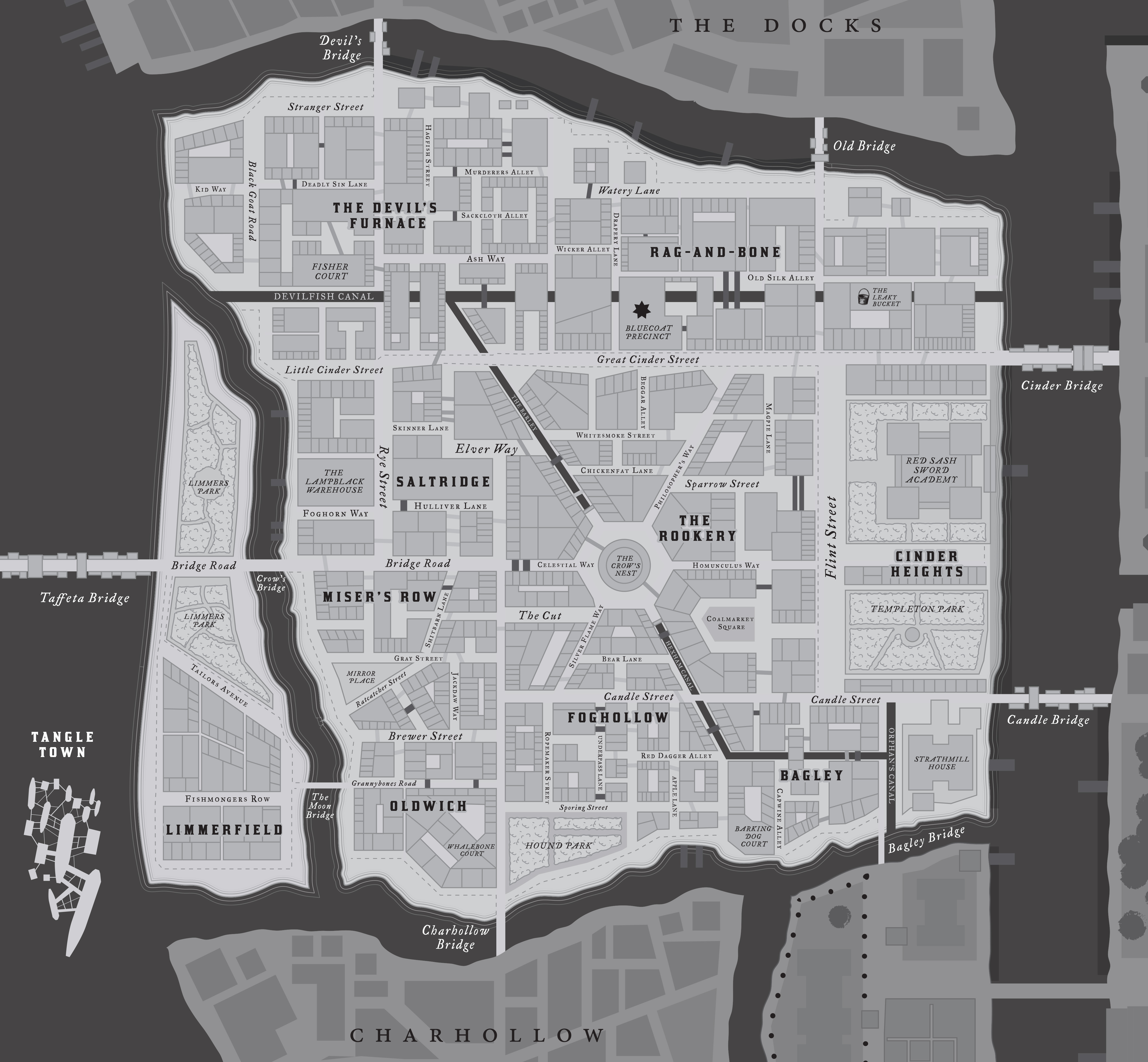
Inspired by the preview of the awesome Coalridge detailed map used in the Bluecoats playtest, I decided to try making a detailed map of Crow’s Foot (since it’s the starting situation).
Zoom in for the details! You can get it from my Crow’s Foot folder if you want to use it: https://drive.google.com/open?id=16FTxODZKtLiWI0FlgyYde_B9vDLAp40Q
Thanks for sharing!
How does a wagon passing north to south through this Doskovol’s Crow’s Foot cross the Devilfish Canal? Does a Ferry Guild find a way to sabotage every bridge initiative?
nice!
You’re art is always such a treat. Thank you for continuing to post and share it with the community.
This is awesome.
Gart Larissa There is a North Crow’s Foot reachable over the Old Bridge and a South Crow’s Foot reachable over the Cinder Bridge. That’s the way it always has been (from this moment onward)
These map explosions are cool! Love the building cutaway as well. 😀
Gart Larissa Clemens Schmitz Hah, well, truth be told that’s definitely an oversight, but I like both your answers much better! I also imagined some drawbridges along the canal, since drawbridges are always exciting in a chase-scene.
Michael Elliott Hey cheers Michael, appreciate that!
I love this so much.
Tim Denee, it’s people like you that make this game even greater. I would pay money for your work. Thank you for doing this!
Ben Liepis Well thank you very much!
Love it! Would you be looking to make on for U’duasha anytime soon? My campaign is set there and a more detailed map would be amazing!
nychelle smeltzer Not any time soon but I’ll add it to my list! I was going to do the Doskvol Docks next… (not sure when).
Your art is so good. I would love nothing more than to see your imagery for the rest of the city.
Tim Denee, so…can you sell the crack or not? We needses it, Bagginses! 😁
Ben Liepis Kyle Schlahta I would love to do more! Unfortunately it’s more an issue of time than money… But I should really do another one.
Tim Denee, package it in some way. Maybe with chicken nuggets or tacos. It matters little. Then…and this is crucial…get it into the hands of every Blades player around!
I would totally dig a folio of these maps that could be marked on. Perhaps printable for use in several games?
Any chance we can get this as a pdf? Scales better for printing. Love the work!
Adam Brimmer Good call, here you go: drive.google.com – crowsfoot_zoom.pdf
And, incidentally, I’ve been working on the rest of the city (!?). I’ll probably release it all together as a combined package.
Tim Denee Gosh please keep us in the loop! 🙂
Secretly hopes and wishes that he will do U’duasha as well so she can use the beautiful maps for her campaign.
Any help you need to expand on this – from establishment to street names to design elements – let me know. I’ve always thought Charterhall should mimic the city of Valletta… full of churches, chapels, government ministries housed in 16th century palazzos and one of the islands earliest red light districts. https://bit.ly/2KUwtVx
Adam Brimmer Neat idea – flick me an email at timdenee at gmail, happy to have the input! I’m avoiding labelling buildings/establishments as much as possible so that the map has enough blank spaces for everyone’s different versions of Doskvol, but street/canal/bridge names and such are very welcome.