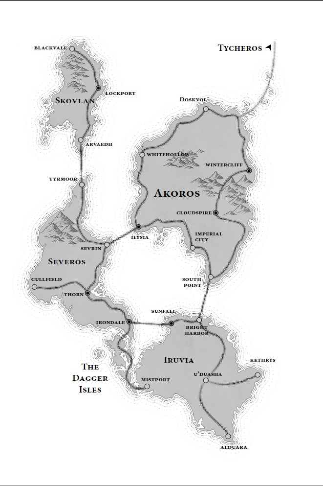
I have a kinda inconsequential question about the map of the Shattered Isles: What, if any, is the distinction between the cities marked with black dots and those with clear ones? Is that meant to signify something about those locations?
Bonus question: Do you think the stops on the rail lines are the only holdouts of civilization that remain after the cataclysm? It’s said that the people on the Dagger Isles live without lightning barriers, but for everywhere else, I imagine the idea is that humanity has had to retreat to the few locations where enough resources could be pooled to erect the barriers, so the relatively few major cities shown on the map are the only places people can live at all now.
Asked a different way, do you think this is a map primarily showing the major stops on the rail lines (but excluding other cities), or is this a comprehensive view of civilization in the Shattered Isles?
Posting to see what folks say about question #1. I don’t have any idea, myself! It’s interesting that Doskvol is one of the white dots.
As for question #2, I know the Severosi are nomads. I suspect (but am not certain) that means they live without lightning barriers at least part of the time. The book talks about how the land outside the lightning barriers is all ghosts and ash, but we know there are a few crews operating in the deathlands around Doskvol. So maybe living outside a lightning barrier happens everywhere, but only if you stay pretty close to a settlement with a lightning barrier?
I could be wrong but I think it’s a holdover from the original shattered isles map from Ghost Lines: onesevendesign.com
The tracks are colored red and black to help differentiate lines; you can easily see where the Upper Skovlan line becomes the Lower Skovlan line (in Lockport). I think the red-dots-with-black are junctions or hubs where you transfer from one line to another. Duskwall isn’t a junction because it’s actually a midpoint on the Duskwall line, but Wintercliff is where you transfer from the Duskwall line to the Pass line.
At least, that’s my guess!
For question #2, I do tend to assume that this is the entire extent of civilization, barring a few interesting but very small communities (such as Severosi nomads and Dagger Isles villages). I also allow fictional room in my mind for, say, a Skov fishing village protected by old standing-stones graven with runes, or an ancient castle in the deathlands where an eccentric scientist has taken up residence protected by a small lightning barrier.
Just havin’ fun, but I like the idea of the junction cities for the lines.
https://lh3.googleusercontent.com/Or8jNtiAOI2cioUDejbOGigv_ZC_qcXwwdFw1hlG52E1XDJbzMfAlXVBFY_6d-CwmHEvBy_XEjpb6r9TtT0KrGoK6muHo0sAX0Hk=s0
Michael Derr Ah, it’s cool seeing it drawn out clearly like that! It’s interesting that Akoros and Iruvia share the largest major line– implying trade/travel happens more regularly between them than with Severos and Skovlan? o.O
Tim Denee That definitely makes sense and seems consistent with the Ghost Lines map, good call!
I agree/like the idea that what you see on this map are the only major locations where anyone is able to live anymore. The sort of post-apocalyptic aspect of the Blades setting is one I didn’t really pick up on at first, but I think it’s interesting. I do also like the idea of there being some odd exceptions to that rule as well. Establishing that everyone has to gather within the few major cities to survive makes it all the more spooky when people don’t ^_^
How did they build the long bridges? We don’t even do that now. And wouldn’t the leviathans knock out the supports periodically? I would think travel between the islands would have to be ships.